


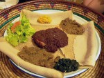
Ethiopian Chicken Stew (Doro Wett)
Ethiopia
amantour
guides you to the best local dishes & drinks in
125+ cities. See map now


Now on Amazon.com!

Download our New York City Food & Travel Guide to your Kindle, smartphone, or tablet and learn how to eat like a true New Yorker: 23 local dishes plus an exclusive walking food tour in Queens. $3.99
EYW wants your food photos!

EYW wants your food stories!
Hey guys I am a traveler who loves to explore different places around the world. I often visit outside of Canada, So whenever I have to travel around the world I always book my flight tickets from the... Read more


WALK
Clearly, you’ll be walking a lot in NYC—it’s a saving grace, really, for all those New Yorkers who love their food so much (ahem). So skip the pricey taxi whenever you can and experience the city on foot, as it’s meant to be—through gorgeous Greenwich Village, among the brownstones of the Upper West Side and Park Slope, past the East Village’s countless shops and bars, in and out of the art galleries of Chelsea and Dumbo. And consider some of these favorite walking destinations.

• When it’s completed, the High Line, a public park built on a 1930s elevated rail line on Manhattan’s west side, will be 1.45 miles (2.3 km) long; as it stands now, it’s about a one mile one way, running from Gansevoort St. in the Meatpacking District to 30th St. in Chelsea, between 10th & 11th Aves. (map). This isn’t hugely exerting, of course, but it’s a worthwhile stroll along a beautifully landscaped, coolly repurposed industrial structure, high above the city streets.
• It’s an oldie but a goodie: Walk over the Brooklyn Bridge. It’s a must. The historic span itself is just more than a mile (1.8 km) long, but add in some of Lower Manhattan beforehand and Brooklyn Heights/Brooklyn Bridge Park after (or vice versa), and you’ve got a full day of the best kind of sightseeing—on the ground, among locals and jaw-dropping views, while burning calories. Of course, there are a few famous culinary temptations, particularly on the Brooklyn side (Grimaldi’s, Brooklyn Ice Cream Factory, Jacques Torres Chocolate), and we’re not going to discourage you from any of them.
• Get to know Central Park (pictured at top) by walking its entire length (about 4 miles/6.4 km), from Columbus Circle to Central Park North—with optional detours for Frisbee, volleyball, a rowboat rental on the lake, or additional mileage on the park’s 58 total miles (93.3 km) of pedestrian paths. This map will help you plot a path.
• Organized walking tours are a wonderful way to learn more about the city, whether it’s history, culture, food, or even beer you’re interested in. Check out the tours on offer from Big Onion and Urban Oyster; one particularly fascinating tour, offered by journalist Joshua Bernstein, explores New York’s vast homebrewing scene (which, as we once blogged, concerns some very good beer). History buffs might consider the interesting tours offered by Queens borough historian (and urban geography professor) Jack Eichenbaum.
BIKE
New York City has gotten increasingly bike-friendly in recent years, with more than 700 miles (1,126 km) of bike lanes across its five boroughs working to make travel safer for everyone on the road. In spring 2013, the city finally launched its own bike-share program, Citi Bike, which is great for locals and visitors alike (ideally, though, you bring your own helmet). Check out the (soon-to-expand) station map, get your bike, and go! Pricing starts at $9.95 for 24-hour access, for which you get an unlimited amount of 30-minute trips. Updated bike maps can be found here, and a route-planner here.
One of the city’s best biking routes is the Hudson River Greenway, an 11-mile (17.7 km) stretch of separated bike (and walking) path that travels up Manhattan’s west side adjacent to the Hudson. It is only one section of the still-under-construction 32-mile (51.5 km) Manhattan Waterfront Greenway, which will circumnavigate the whole island (it is possible to do so now by using on-street links here and there; see the map here), but the west side is our favorite part, especially come summertime. Among the highlights are several casual al fresco dining and drinking spots, like the super cool seasonal Frying Pan bar-on-a-ship (W. 26th St. & the river, map) in Chelsea and the Boat Basin Café (W. 79th St. & the river, map) on the UWS; beach volleyball at the Hudson Beach Café (105th St. & Riverside Park, map); and The Cloisters ($25; 99 Margaret Corbin Dr., Fort Tryon Park, map), the Metropolitan Museum of Art’s castle-like offshoot, a treasure trove of art and architecture from medieval Europe.
There are a number of places to rent bikes on the west side; the Waterfront Bicycle Shop ($32 per day; 391 West St. nr. Christopher St., map) is conveniently located near the Greenway’s southern end.
Alternatively, rent your wheels at Bike Rental Central Park ($40 per day, or $32 if booked online; 348 W. 57th St. betw. Eighth & Ninth Aves., map) to explore the leafy 843-acre urban oasis via its 6.1 miles (9.8 km) of hills and flats. The company also offers bike tours of Central Park and the Brooklyn Bridge. (To pedal around CP’s Brooklyn sister, Prospect Park, check out Ride Brooklyn (from $30 “until close”; 468 Bergen St., map) bike rentals in Park Slope.) And if you are headed to Brooklyn—where lots of crazy new things are happening in terms of improved public space—be sure to check out this map of the nearly completed Brooklyn Waterfront Greenway.
©2024 Eat Your World, LLC - All Rights Reserved